
What Is RTLS?
How Real-Time Location Systems Work
Understand the technologies, architecture and real-world applications behind tracking people, assets and vehicles.
Last Updated : September 16, 2026
Overview
A production supervisor is ready to move a material trolley to the next stage of manufacturing, but the trolley is nowhere to be found. While the team searches, a manager receives an SOS alert from a worker and needs to know exactly where help is required. Nearby, another team is looking for a forklift and a critical piece of equipment.
This is how a normal day can look like in a manufacturing plant, where people, materials, tools and vehicles are constantly moving between production areas.
Different problems, happening at the same time, but all with the same underlying need: knowing where people, assets and vehicles are when it matters.
This is what a Real-Time Location System, or RTLS, makes possible: it provides real-time visibility into the location and movement of people, assets and vehicles, helping organizations improve safety, efficiency and operational control.
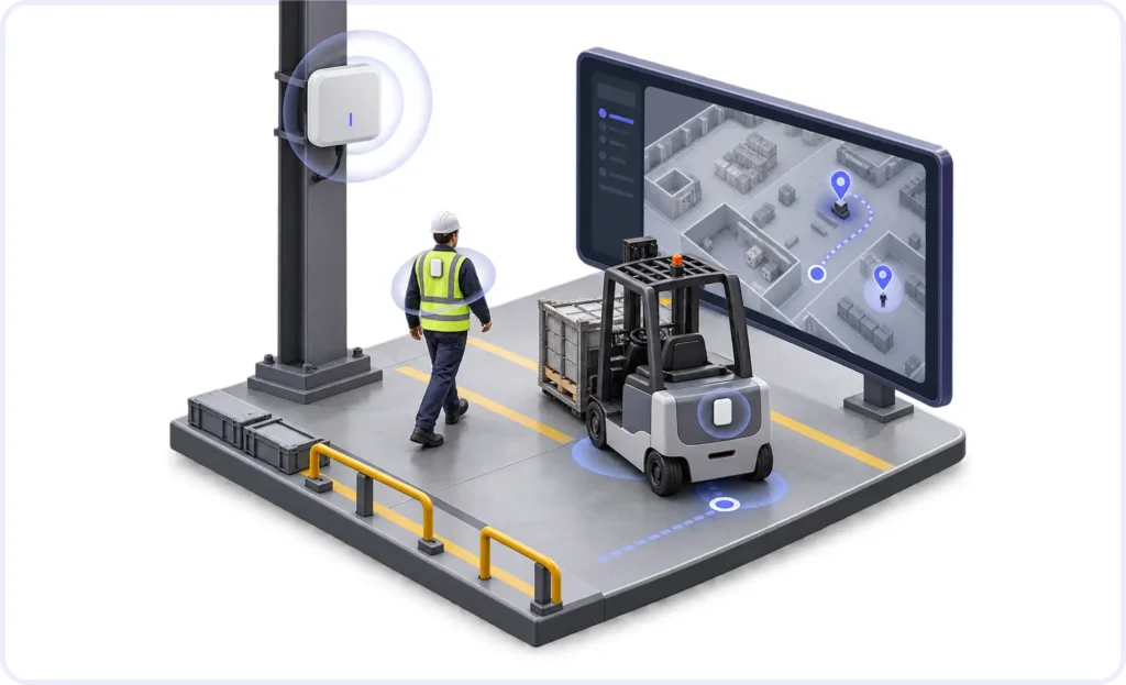
RTLS combines wireless technologies, location infrastructure and software to automatically determine and display the location of tagged people or objects within a facility, campus or defined operational area.
The adoption of real-time location technology is also expanding rapidly. According to MarketsandMarkets, the global RTLS market is projected to grow from $6.68 billion in 2025 to $15.67 billion by 2030, driven by increasing demand for asset visibility, personnel tracking, operational efficiency and safety across industries.
Unlike GPS, however, RTLS is not one specific positioning technology. Depending on the required accuracy, environment and use case, an RTLS can use technologies such as Bluetooth Low Energy (BLE), Bluetooth Angle of Arrival (AoA), Ultra-Wideband (UWB), RFID or GPS/GNSS. Communication technologies such as LoRaWAN can also be used to carry location and safety information across large industrial facilities.
Key Takeaways
RTLS is a system, not a single wireless technology.
Different positioning technologies can be used depending on the application.
Accuracy can vary dramatically.
BLE RSSI may be sufficient for zone-level visibility, BLE AoA can provide sub-meter positioning under suitable conditions, while UWB can achieve centimeter-level positioning.
Indoor and outdoor tracking often require different positioning technologies, but they can be combined into a single hybrid RTLS solution.
BLE and UWB are commonly used indoors, while GPS/GNSS is better suited to outdoor positioning. A hybrid system can switch between these technologies as people or assets move between indoor and outdoor environments, while maintaining a unified platform.
LoRaWAN is generally a communication technology rather than the positioning technology itself.
It can provide long-range, low-power connectivity for transmitting location, SOS and telemetry data.
The right RTLS depends on the problem being solved.
A facility that only needs to know which production area contains an asset does not require the same infrastructure as an application that needs to locate a moving object within 20 cm.
What Does RTLS Mean?
RTLS stands for Real-Time Location System.
An RTLS automatically identifies the current or most recently determined location of a person, asset, vehicle or other tagged object within a defined environment.
A typical system consists of:
Tags or badges attached to people, equipment or assets.
Anchors, locators or reference points installed at known locations.
A communication network or gateway that carries location information.
An RTLS engine that calculates or interprets the position.
Software and dashboards that display locations, generate alerts, maintain history and integrate location data with other business systems.
The exact architecture changes depending on the positioning technology being used.
How Does an RTLS Work?
At a high level, most RTLS architectures follow a simple flow:

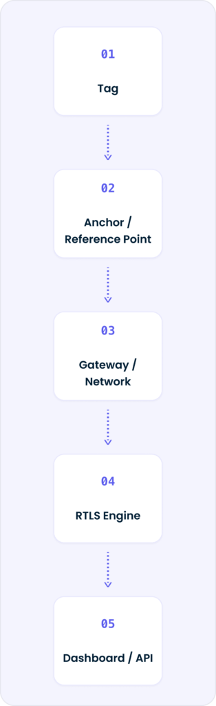
The tag transmits or receives wireless signals. Fixed infrastructure installed throughout the facility observes those signals or provides location references. The RTLS software then determines the location and associates it with the correct person or asset.
That position can be displayed on a floor plan or map, stored as historical movement data, used to trigger geofence rules, or sent to another system through an API.
For personnel-safety applications, the same tag can also transmit information such as SOS alarms, fall events or other sensor data.
The important point is that not every RTLS calculates location in the same way. The technique depends on the technology being used.
Which Technologies Are Used in RTLS?
One of the most important decisions in an RTLS deployment is choosing the appropriate positioning technology.
These figures should always be treated as deployment-dependent rather than guaranteed specifications.
For example, Bluetooth Direction Finding uses techniques including Angle of Arrival (AoA) to determine the direction of a Bluetooth signal. The Bluetooth SIG states that Direction Finding enables high-accuracy positioning, while also noting that obstacles and reflecting surfaces can affect real-world performance through multipath propagation.
UWB uses very short radio pulses and precise time measurements to determine distance. The FiRa Consortium reports centimeter-level capability and notes that, in challenging environments such as factory floors, UWB positioning can be approximately 30 cm with 95% reliability.
This is why an RTLS should not be selected simply by asking, “Which technology has the best accuracy?”
The better question is:
“What level of location accuracy does this application actually need?”
Where Is RTLS Used?
RTLS is particularly valuable in environments where the location or movement of people and assets affects productivity, safety or operational decision-making.
In manufacturing, RTLS can track material, tools, work-in-progress, containers, forklifts and other mobile equipment.
In automotive plants, location information can help track material movement between production stages, monitor returnable containers and provide visibility into mobile assets.
In warehouses and logistics facilities, RTLS can locate pallets, equipment, vehicles and personnel across operational zones.
In healthcare, RTLS can help staff locate medical equipment and other high-value mobile assets.
For personnel safety, wearable RTLS badges can combine location tracking with SOS alerts, geofencing, fall detection and other safety functions.
The same RTLS platform may therefore solve very different problems depending on the tags, sensors, positioning technology and software rules being used.
Indoor RTLS vs Outdoor RTLS
Indoor and outdoor environments create very different positioning challenges.
GPS works extremely well outdoors where there is a clear view of the sky, but its signal can be affected by atmospheric conditions and severe weather. It also becomes unreliable or unavailable inside many industrial buildings.
Indoor systems therefore typically rely on technologies such as BLE, BLE AoA or UWB.
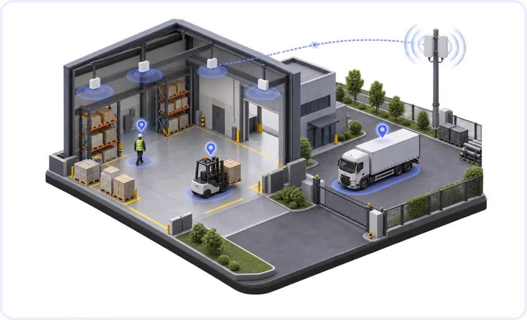
Large industrial campuses may require both.
For example, SYTRAK has designed hybrid personnel-safety architectures where BLE provides indoor location awareness, GPS provides outdoor positioning, and LoRaWAN carries location and SOS information across a large industrial campus.
The LoRa Alliance describes LoRaWAN as a technology designed for IoT applications requiring long-range connectivity while maintaining low power consumption, which makes it useful as a communication layer in distributed RTLS architectures.
A hybrid approach allows the positioning method to change as a person moves between indoor facilities and outdoor areas while maintaining a common RTLS platform.
Real-World RTLS Performance Matters More Than Datasheet Accuracy
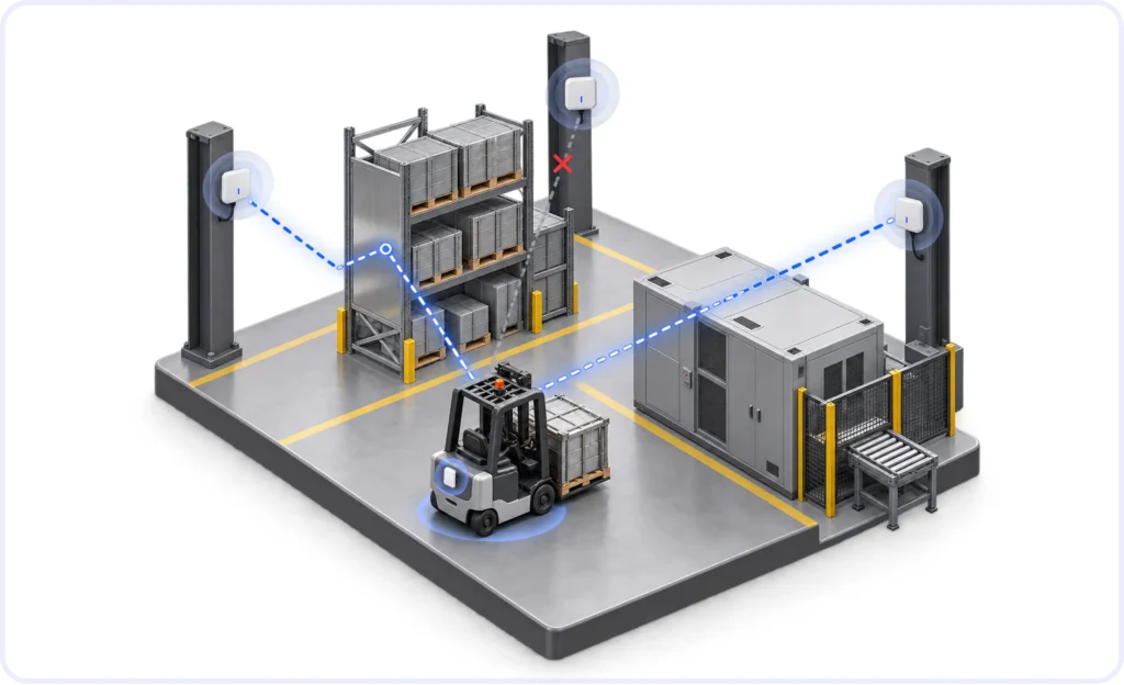
RTLS performance measured in an open test area does not necessarily represent what will happen inside an industrial facility.
Metal structures, machinery, walls, storage racks, tag orientation, anchor placement, installation height and RF reflections can all influence positioning performance.
This becomes particularly important in manufacturing.
In one automotive manufacturing use case, SYTRAK evaluated UWB positioning in a metal-dense production environment for tracking material movement through production zones.
Such environments are valuable RTLS tests because they contain large metal structures, machinery and moving objects that can introduce multipath and non-line-of-sight conditions.
It is therefore important to distinguish between:
Technology capability and accuracy that can consistently be achieved in the actual facility.
Site design, infrastructure density and validation are as important as the positioning technology itself.
How Do You Choose the Right RTLS?
There is no universally “best” RTLS technology.
A useful starting point is to determine:
What needs to be tracked?
Will it be indoors, outdoors or both?
Is zone-level visibility sufficient, or is sub-meter or centimeter accuracy required?
How frequently must the location update?
What battery life is expected from the tag?
What communication and power infrastructure already exists in the facility?
A BLE-based system can be significantly simpler when the requirement is only to identify the area containing an asset.
A UWB system becomes valuable when knowing the precise position of that asset materially changes the operational outcome.
The RTLS architecture should therefore be designed around the business requirement first and positioning technology second.
RTLS Is Ultimately About Location Intelligence
RTLS does more than place a moving dot on a map.
Once reliable location data becomes available, it can be used to answer operational questions:
Where is an asset now?
How long has it remained in this zone?
Did it enter a restricted area?
Which route did it follow?
Where was a worker when an SOS alarm was triggered?
How long does material normally wait between production stages?
This is where RTLS evolves from a tracking system into a source of location intelligence for operations, automation and safety.
Planning an RTLS Deployment?
SYTRAK provides end-to-end RTLS solutions across BLE, BLE AoA, UWB, GPS and hybrid indoor-outdoor architectures, covering tags, anchors, gateways, RTLS software and system integration.